locations

...now browsing by category


A strange visitor at Badwater

Tuesday, February 23rd, 2010

This weekend, a friend and I drove to Death Valley National Park.  I had heard there is currently water in Badwater Basin, and wanted to see it, as well as photograph it.  Since Death Valley usually does not get enough rain to allow for standing water in the basin, this is a rare event (since January 1, Furnace Creek has received over 2″ of rain).  On Friday, we arrived at Badwater about 3pm, and immediately headed to the West Side Road in search of photo opportunities.

On Friday, another storm moved into the area.  In my experience, bad weather can either lead to amazing light conditions, or to very poor conditions for photography.  Unfortunately, in this case, it was the latter.  There wasn’t much of a sunset on Friday night.  However, after dark, we headed back over to the Badwater parking area and walked out on the salt flat.  Because conditions were poor for star trail photography, my friend and I did some light graffiti–one of his newest hobbies.  I have to disclose that I really did nothing here, except for stand behind the camera, but this one is called ‘Badwater Blooms’.

light graffiti on Badwater Basin in Death Valley National Park, California

"Badwater Blooms", Death Valley National Park, February 2010

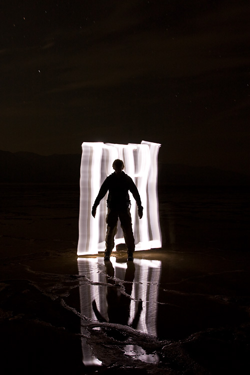
As we were experimenting with different bloom configurations, the strangest thing happened.  We thought we were alone on the salt flat, but off in the distance, we could make out a figure walking towards us.  Ours was the only car in the parking lot, and no one had arrived, so we tried to say hello, thinking the person may be lost or need help.  The figure didn’t say anything, but as it got closer to us, a bright light appeared behind it, and the figure disappeared, almost as quickly as it had appeared.

I managed to snap this photo before it disappeared.

a strange silhouette in Badwater Basin, Death Valley National Park, California

A strange visitor, Death Valley National Park, February 2010

Was the visitor from another dimension?  Did it exit through a portal that’s only open when Badwater Basin is full of water?  I’m not sure.

Unfortunately, we didn’t have much better light the next morning; in fact, we had really poor light.  However, Saturday night, we had the best light I’ve had in quite some time.  I’ll share those images in my next post.

You can see all my Death Valley images here.

More from the Superstitions

Thursday, February 18th, 2010

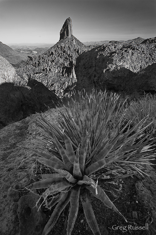
Sometimes the best-laid plans just don’t come to fruition.  On our recent visit to Phoenix, I planned to get up very early (i.e. ~4am) drive to the Peralta Canyon trailhead and hike ~3 miles to the Weaver’s Needle Overlook to watch the sun come up, and to get that really sweet crepuscular light that happens in the desert.  Easy enough, right?  I ended up having a couple of roadblocks on my journey to ‘the Supes’.

  • Roadblock #1.  Two days before I intended to hike, I came down with the worst head cold I’ve had in several years.  I’ll spare you the mucus-y details, but use of my nostrils was completely nonexistent, and my head felt like it was completely detached from my body.  As a result, a 4am departure time didn’t seem feasible.  I settled on getting up at 4:50am, figuring that if everything went smoothly, I’d still make it up to the overlook by 7:15am sunrise.
  • Roadblock #2.  Of course everything didn’t go smoothly.  I really like Phoenix–its a great town, and its super easy to navigate as the streets are laid out in a logical grid pattern.  That said, there are exceptions, and a poorly marked detour can throw an out-of-towner like me out of whack.  Driving from my sister-in-law’s house, I wanted to connect from I-10 to US Hwy 60 to drive to the Superstitions.  The connector ramp was closed, and the flashing sign said to take I-10 to McClintock instead.  OK.  After driving nearly 15 miles south (I wanted to go east), I finally stopped and asked for directions.  I got on my way then.  OK, well, that cost me about 15 minutes.  But if I really hoof it, I can make it, right?
  • Roadblock #3.  I finally made it to the Peralta Road east of Apache Junction, and as I began driving the 7 miles toward the trailhead I was met by school buses.  Lots of them.  School buses…on a Forest Service road on a Sunday.  What doesn’t compute here?  After I met the school buses, I was met by runners.  Lots of them.  It turns out it was the annual running of the Lost Dutchman Marathon, and I was driving up their course!  After slowly navigating several hundred finish-line-bound runners, I finally made it to the trailhead about 6:50am–25 minutes before sunrise.

I like to say that I’m a pretty fast hiker, but I’m not that fast.  I didn’t make it to my destination by sunrise, but the hike was nice, and in hindsight the chain of events I encountered getting to the trailhead were almost comical.  I even ended up with a nice photo or two out of the deal.  It was definitely a good lesson not to take things so seriously.  Things won’t always come together as you planned, but if you fail to see the forest for the few negative trees, you’ll miss out on some great experiences.

Weaver's Needle from Weaver's Outlook Ridge, February 2010

Weaver's Needle from Weaver's Outlook Ridge, February 2010

Those Mighty Superstitions

Monday, February 15th, 2010

A few years ago I had the opportunity to go backpacking for a week in the Superstition Wilderness east of Phoenix.  Two things struck me then about this area: its stunningly beautiful, and it doesn’t matter how you slice it, this is one rugged area.  Although I was “into” photography at the time, I didn’t carry a camera with me, and since then I’ve been itching to get back to those mighty Superstitions.

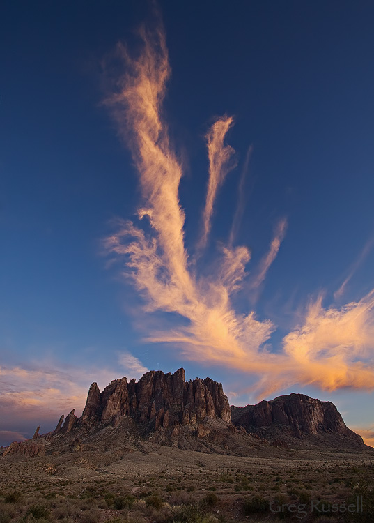
My wife’s sister lives in Phoenix, and we’ve found ourselves here visiting a few times this winter.  Its given me an opportunity to revisit these mountains.  In January, I visited the Lost Dutchman State Park*, and hiked around the western flank of this magnificent range.  I had a fantastic sunset, and had the opportunity to get a short hike in–up the Siphon Gulch trail.

Superstition mountains from lost dutchman state park

Cloud above the western flank of the Superstition Mountains, January 2010

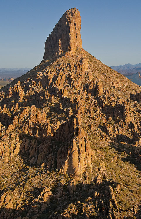
Yesterday morning, I was able to visit the Superstitions again.  This time, I drove to the eastern side of the range and hiked up the (very) popular Peralta trail to photograph Weaver’s Needle.  I wanted the morning light on this spire, so I was on the trail before sunrise.  It was a good thing too: the trail’s proximity to the greater Phoenix area makes it extremely busy.  On my way down, I must have passed 50 people on their way up!  My early start ensured I got good light on my subject, but also that I got the place to myself.  The solitude was very rewarding.

Weaver's Needle in the Superstition Wilderness, Arizona

Weaver's Needle, February 2010

After visiting this place again after several years, I can say that its just as beautiful as I remember it.  I can also say that its just as rugged as I remember it!  Man, this is one amazing place.

I’ll be sharing more images from the Superstitions over the next week, but in the meantime, you can view them all here.

House on Fire ruin–a vertical panorama

Monday, February 8th, 2010

In my last post, I discussed a few techniques that can be used to effectively shoot panoramas.  All of my examples were of grand landscapes, and they were all landscape-oriented panoramas.  I want to use this post to point out another time you can shoot panos to yield great results.

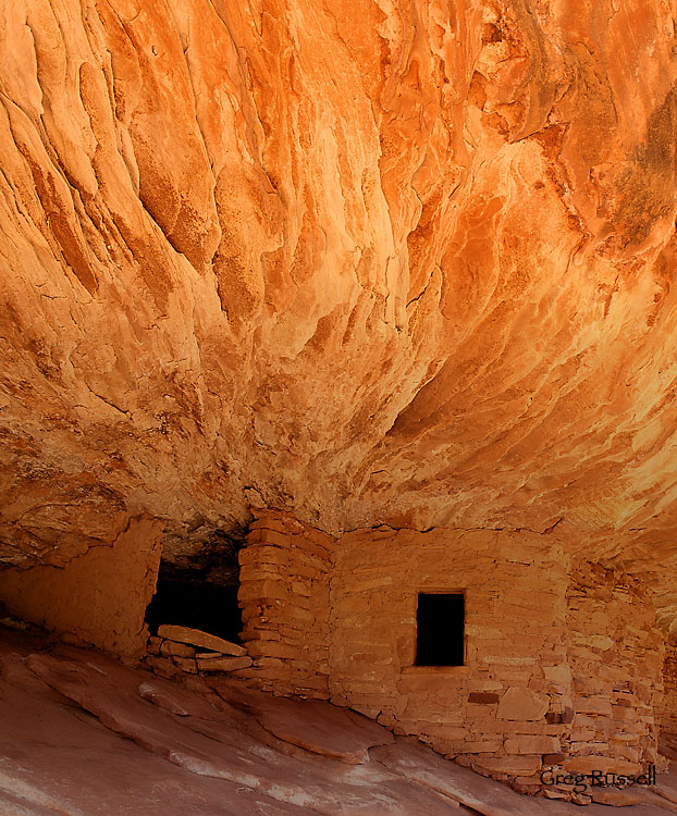
Last November, we visited the Cedar Mesa area near Blanding, Utah.  Since we were limited on time, we chose to visit a familiar and often photographed Ancestral Puebloan ruin that’s been nicknamed the “House on Fire” (also called the Flaming Roof ruin).  I blogged about that visit here, in November.  While at the ruin, I envisioned someday wanting to print it very large, and wished I had a medium format camera with me.  Additionally, I really wanted to emphasize the “flames” exiting the roof of the ruin.

So, I took 3 landscape-oriented images, but rather than putting them next to each other, I stacked them on top of one another,  thus producing a larger image.  If you click on the image, you’ll see a larger version–the detail is amazing!  That said, it would look even better printed on canvas over your couch 🙂

A view of an Ancestral Puebloan ruin near Cedar Mesa, Utah

"House on Fire" vertical panorama, Utah, November 2009

Photo of the Month-February

Monday, February 1st, 2010

I really cannot believe that January–1/12 of 2010–is already behind us.  It seems like just yesterday we were all sharing our favorite images of 2009, and we’ve already created so many fantastic images this year.

Here in southern California, the weather is already starting to feel spring-like.  Around my house, the hillsides are turning the vibrant green that will be with us until April.  There’s talk of a decent wildflower season after our epic rainfall totals during the last couple of weeks.  While our spring will have moved into summer by the time the rest of the nation begins theirs, I’m looking forward to all of those spring time photo outings–the ones where you (should) take just a few moments to bask in the warm sunlight, or in a grass-filled meadow.  I’m also looking forward to hopefully fitting in our annual trip to Death Valley National Park this year.

If you haven’t been, Death Valley is a pleasantly deceiving national park.  The idea of “DEATH Valley” brings to mind a barren landscape that’s, to put it bluntly, boring.  Anyone who’s been there will tell you the opposite.  Its an amazing park, encompassing many ecosystems, and several natural wonders.  What amazes me is how much diversity is present in a relatively small space.

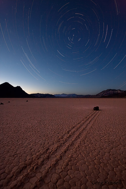
One of my favorite places in Death Valley is the Racetrack Playa, where the famed “racing rocks” are found.  The playa itself is a very flat surface; its altitude varies only a few centimeters across its 1-mile length!  When the playa is wet (as it probably is now), it makes a very slick surface, and high winds push the “racing rocks” along, leaving tracks that remain after the mud has dried.  Many of the rocks are quite large, and I’m happy I haven’t been on the playa during the winds that are capable of pushing rocks that heavy–I would guess there would have to be gusts in excess of 80 or 90 mph!

This month’s photo is a star trail shot I took in April 2009 on the Racetrack.  It is a composite of about 25 2.5-minute shots, stacked using Photoshop.  I wanted to include the north star–Polaris–in my shot, so I had to look for a rock that had a northerly trajectory–apparently there aren’t many!

racetrack star trails

Star trails on the Racetrack Playa, Death Valley National Park, April 2009

G. Dan Mitchell, an excellent San Francisco Bay Area photographer, has recently been writing a couple of very informative and comprehensive guides to visiting Death Valley.  You can see them here and here.  Mac Danzig, who has an amazing Death Valley portfolio, also has taken the time to write an excellent guide to Death Valley here.

You can see all of my Death Valley photographs here.

Bryce Canyon sunrise

Wednesday, January 27th, 2010

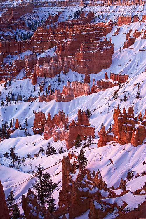
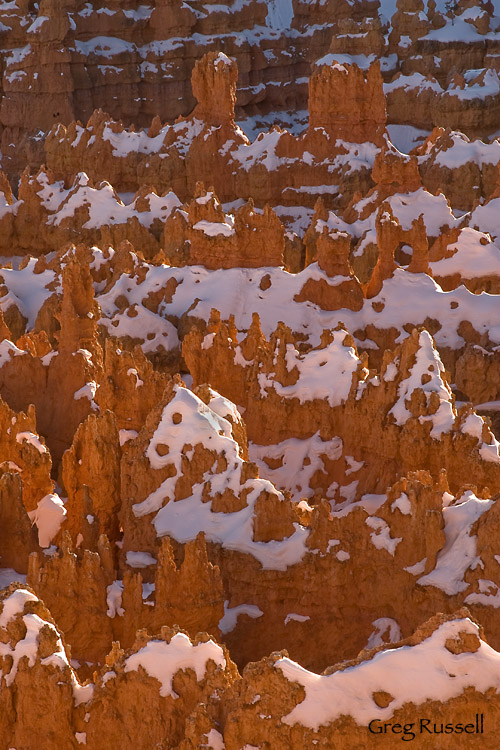
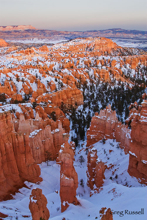
As I promised in my last post, here are a couple of sunrise photos from my recent trip to Bryce Canyon National Park.  Although it was my first sunrise in the park, anyone would quickly realize that Bryce is truly a place to see the sun come up!  We elected to go to Sunrise Point, and although it was very pretty, I’m convinced Sunset Point would have been equally as beautiful.  After waddling (I say ‘waddling’ because the trail from the parking area is was steep and icy) carefully to the point, we enjoyed near solitude as the horizon was beginning to light up an intense red color.  I’m pretty sure this red was at least partly due to emissions from the Navajo Power Plant, almost 90 miles away in Page, Arizona, but it was still very pretty.  Within minutes, the snow in the Amphitheater was glowing pink, and the hoodoos were beginning to light up.

Early morning light on the Amphitheater, Bryce Canyon National Park, Utah

Morning Alpenglow, Bryce Canyon National Park, Utah, January 2010

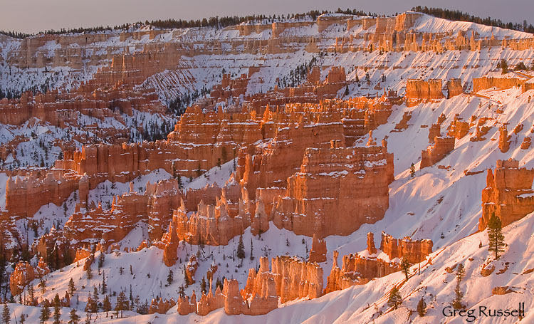
As soon as the sun came up, the entire Amphitheater enjoyed a brief, glorious, glow that lasted only a few minutes.  Within about 20 minutes of the sun cresting the horizon, the show was over.

Sunrise, Bryce Canyon National Park, Utah

Sunrise, Bryce Canyon National Park, Utah, January 2010

Not only is Bryce perfectly suited for early morning shots, its good proof to the photographer that it really pays to be there early!  To see all of my images from Bryce, click here.

Bryce Canyon in winter

Monday, January 25th, 2010

After visiting Zion National Park on our recent trip, we went over to Bryce Canyon National Park to spend a sunset and sunrise.  It was my second time visiting Bryce, but during my first visit I wasn’t able to be there during the “golden hour”, so it was nice to spend an evening and a morning there.  Additionally, I was excited to visit while there was snow on the ground; for some reason, Bryce seems like a national park that’s complimented very well by snow.

As expected, the Amphitheater didn’t let down.  We spent sunset at–are you ready?–Sunset Point, and it was very pretty.  In the hour or so before the sun went down, I photographed the lovely backlit hoodoos in the cluster known as the Silent City.

Backlit hoodoos in the Silent City, Bryce Canyon National Park, Utah

The Silent City, Bryce Canyon National Park, Utah, January 2010

However, after the sun went down is when the real show started.  The best way to describe the light at Bryce Canyon may be “magical” or as a “glow”.  Either way, I don’t think those words really do it justice.  After the sun went below the horizon, the entire Amphitheater lit up with this palette of pastels that is simply indescribable.  This photo shows what’s probably Bryce’s most photographed hoodoo–Thor’s Hammer–all the way to the Aquarius Plateau in the distance simply lit up in alpenglow.  What a perfect night to be outside!

Bryce Amphitheater at sunset, Bryce Canyon National Park, Utah

Pastel Sunset, Bryce Canyon National Park, Utah, January 2010

Click here to see all of my images from Bryce Canyon National Park.  In my next post…sunrise at Bryce.

Zion National Park “wildlife”

Thursday, January 21st, 2010

When I pulled into the visitor center lot at Zion a couple of weeks ago, there were 3–three–cars in the parking lot besides my own.  If you’ve been there during the high season, you know that’s unheard of; unless you’re there at 5am, you are not getting a parking spot at the visitor center!  The solitude that comes during winter in Zion is pretty amazing.  In the canyon, there are birds everywhere–spotted towhees, dippers along the river, etc–and driving into the east side of the park, you stand a good chance of seeing desert bighorn sheep.

A desert bighorn sheep (Ovis canadensis nelsoni) in the Zion National Park high country, Utah

Desert Bighorn Sheep (Ovis canadensis nelsoni), Zion National Park, January 2010

We saw several bighorns between the tunnel and the park’s east entrance, and I do not know if I’ve ever seen one there in the summer.  Perhaps they spend the hot summer months at higher elevations, but regardless, it was a real treat to see these sheep.

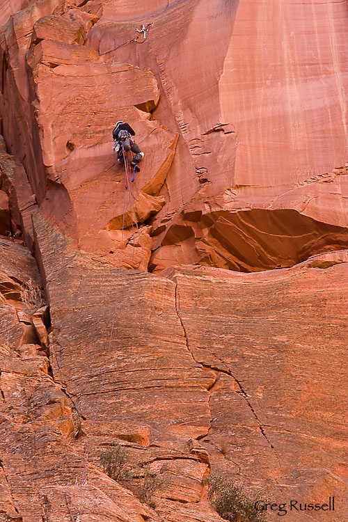
There’s no question desert bighorns are true rock climbing masters; their hooves stick to the sandstone very well.  Amazingly, there is another group of specially adapted rock climbers that is often seen in Zion.  Driving up the canyon, admiring the Virgin River, we ran across a group of these climbers.

A rock climber ascends the route Moonlight Buttress, Zion National Park, Utah

Climber on Moonlight Buttress, Zion National Park, January 2010

Zion is a practically a Mecca for rock climbers.  While I’ve always thought it would be very cool to tackle a rock wall like this, I have never gotten into this kind of climbing.  I’ll leave it to the pros!

To see all of my Zion National Park images click here.  My desert bighorn sheep images (from both Zion and Joshua Tree National Park) can be found here.

A busy 2010

Tuesday, January 19th, 2010

Its been a very busy 2010; so far I’ve taken photos in 3 states, as many national parks (Bryce Canyon, Yosemite, and Zion), and have added 2 new pages of landscapes (here and here) to my website.  I’m finally home in southern California, and we’re in the midst of what the TV weatherman is calling an “epic” series of storms.  This gives me time to catch up on image editing, as well as sharing images here on my blog.

About a week and a half ago, I had two posts on the “icons” (here and here), and I shared several of my images from Yosemite National Park.  The week after returning from Yosemite, we headed to northern Arizona in hopes of photographing parts of the Vermillion Cliffs wilderness.  Wet weather made the dirt roads impassable (bummer), but we spent a couple of days in Zion National Park before heading to our next destination instead.  Zion isn’t as photogenic in winter as in summer or fall, but there are few (if any) crowds, which is virtually an unknown if you’ve visited in the summer!

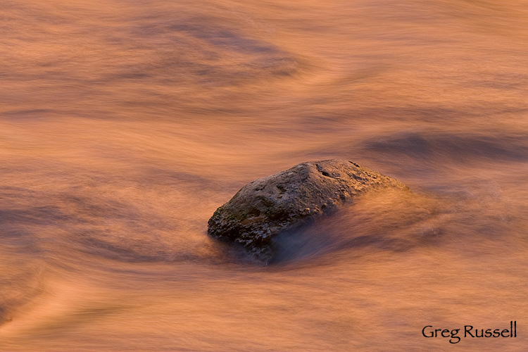
I found winter a great time to explore the more intimate scenery of Zion.  While in the canyon one morning, I was struck by the colorful reflections the sandstone walls were casting on the Virgin River.  By playing with different exposures, I got an intimate, abstract image I’m very happy with.

Sandstone reflects in the Virgin River, Zion National Park, Utah

Virgin River Reflections, Zion National Park, January 2010

In my next post, I’ll share some images of the wildlife that can be found in Zion in the winter…

Book recommendations

Saturday, January 16th, 2010

As a teacher, my spring semester doesn’t begin until February 1, so I’ve had time to do some reading.  I’ve recently finished 2 books that I found fantastic, and would like to recommend them to you.  A little over two months ago, I wrote about how I seem to have been stricken with a bad case of Topophilia.  In trying to reconnect with southeastern Utah, two of the books I’d like to recommend are by David Roberts.

The first book, In Search of the Old Ones: Exploring the Anasazi World of the Southwest, takes the reader along on his 20-year journey through the Southwest and he recounts the history of the discoveries, the appalling thefts of artifacts, the cave paintings and his own transcendent experiences in stumbling upon some vestige of this lost civilization.  His awe and reverence are contagious.

In Search of the Old Ones by David Roberts

Click the image or here to purchase this book from Amazon.com.

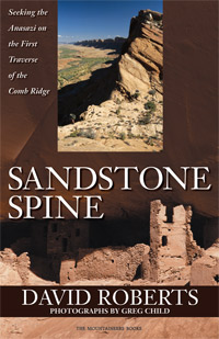
The second book, also by David Roberts is Sandstone Spine: Seeking the Anasazi on the First Traverse of the Comb Ridge. Fueling both my Topophiliac tendencies and my desire for adventure, this book describes–as the title says–the first traverse of Comb Ridge, which runs almost all the way from Kayenta, Arizona to Blanding, Utah.  Its a fantastic, fun read.

Sandstone Spine by David Roberts

Click on the photo or here to purchase the book directly from the publisher, The Mountaineers Books.

Finally I have an unsolicited, but heartfelt recommendation for a photography guide.  On July 10, 2006, on my first trip to Yosemite National Park, I purchased Michael Frye’s The Photographer’s Guide to Yosemite and have found it to be a continued valuable resource.  Buy it and study it; most of the locations are easy to get to, and the superb advice will have you there at the right time of day.  You can click here to see some of the images I’ve made in Yosemite using this book as a reference.

Michael Frye, The Photographer's Guide to Yosemite

Click on the image, or here, to purchase this book directly from the Yosemite Association.