utah

...now browsing by category


Featured Photographer–Guy Tal

Friday, November 13th, 2009

Guy is the third featured photographer in my series on Topophilia, finding your sense of place in the canyons of southern Utah.

In my next post, I’ll be writing about the grand, wide open landscape that draws tourists and photographers to southern Utah.  However, if you look closely, you will also find an intimately beautiful landscape–one that is not immediately apparent, but if you take the time to find it is equally rewarding.

Working on these posts, I’ve enjoyed getting to know my friends a little bit better.  I respect all of their work immensely, and aspire to have as breathtaking a portfolio as any one of them.  Over the course of my photographic career, Guy Tal has inspired me in many ways, but one that stands out is his expertise in bringing the intimate landscape of southern Utah to life.  Whether you’re in Utah or Ohio or Alberta, Guy’s images are a reminder to stop and look at the details.

In his comment on my first post in this series, Guy said:

“This place does something to you. I couldn’t rest until I managed to make a home here, and no other place ever felt more like home to me. More amazing is the fact that I keep discovering it over and over in deeper and more profound ways every time I step out the door.”

Guy’s thoughts crystallize for me the most salient theme in this series of posts: that, in a very real way, going out is really going in.  I have heard that several times throughout my life, but until you actually experience that idea, they really are just words.  I feel fortunate to have a group of colleagues (in other photographers) who feel the same way.


Monets Valley by Guy Tal (used with permission)

Monet's Valley by Guy Tal (used with permission)

You can visit Guy’s website here, and subscribe to his blog here.  In addition, Guy leads photo workshops, with the most recent one being in Capitol Reef National Park.  You can read about them (and sign up for one!) here.

Featured Photographer–Varina Patel

Tuesday, November 10th, 2009

Varina is the second featured photographer in my series on Topophilia, finding your sense of place in the canyons of southern Utah.

In asking other photographers about what draws them to southern Utah, a theme that runs through their answers is the solitude.  During my exchange of emails with Varina Patel, she said it very well:

“Can you think of a spot where you can stand for an hour, and not hear a single car pass by, a single plane fly overhead, or another human voice besides your own? You can find countless spots like that in Utah.”

I think many landscape photographers need that solitude as surely as they need oxygen or water, and they begin taking images as a way to search out and capture that feeling.  Perhaps that’s why so many of us feel at home in southern Utah.

Much of southern Utah is located on the Colorado Plateau, which was uplifted during a series of relatively violent geologic events.  Despite the nature of its creation, the landscapes of southern Utah are amazingly elegant.  That elegance is what drew me to Varina’s photography.  Her compositions are simple, with brilliant lines and colors, and are technically perfect.  Her photos draw you in, letting the lines lead you through the frame, inviting you into the landscape.  Looking at her portfolio, it is evident that Varina–like many other photographers who have fallen victim to the landscapes of the Colorado Plateau–feels a deep connection with the earth.

Varina, with her husband Jay, run multiple workshops, including day workshops on a method of post-processing they have dubbed intelligent HDR (or iHDR).  The idea is to process the parts of the image that actually need an HDR treatment, rather than the whole frame.  The latter has a tendency to make an image look garish or unnatural.  Her expertise in post-processing is evident in looking at her images, and I hope I can achieve that level of understanding…someday!

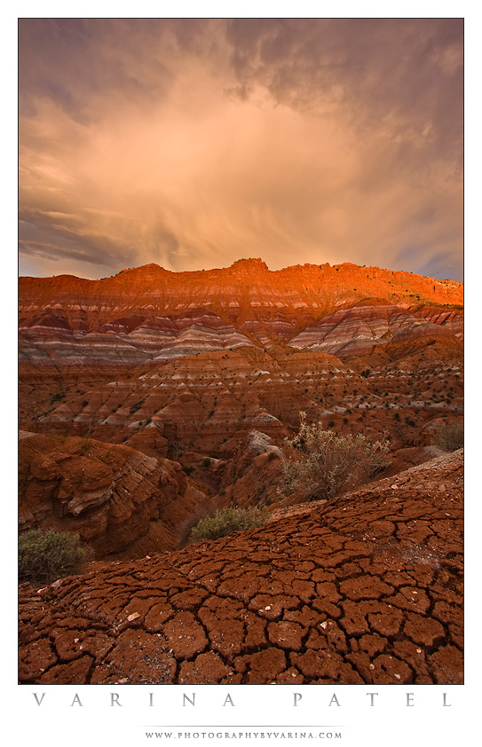
Like Scott Bacon, Varina told me to choose which image of hers I would like to display.  I chose this image, taken in the Grand Staircase-Escalante National Monument.  Varina gave me a fantastic description of the image, and of the landscape.  Rather than me try to butcher her words by paraphrasing, I’ll share her sentiments:

“…this is a spectacular location. It’s in the Southwest region of Grand-Staircase Escalante National Monument. The Native Americans called it ‘The Land of the Sleeping Rainbows.’

The first time we visited this location, we stopped near this spot, and got out of the car. We stood there in awe of the view. Those bands of color you see in the mountains stretch for miles in every direction… and the landscape here is completely unpredictable. We’ve visited this spot several times now, and we’ve only explored a small piece of it. I think I could shoot here for weeks on end, and never get tired of it.

On this particular day, we arrived in time to scout locations before we set up our cameras. We could see these storm clouds rolling in, and were pretty excited about the prospect for some nice shots. The storm clouds were moving fast, and the light was incredible. I found a patch of cracked earth, and used that as my foreground – in an attempt to give the viewer a more intimate view of the location… as if they could step right into the photo.”


by Varina Patel (used with permission)

You can visit Varina’s website here, learn more about her workshops here, and subscribe to her blog here.

Featured Photographer–Scott Bacon

Sunday, November 8th, 2009

Scott is the first featured photographer in my series on Topophilia, finding your sense of place in the canyons of southern Utah.

I’ve only discovered Scott’s work recently, but am very happy I did.  His work conveys to me a simple beauty, one that is achieved when one feels a close connection to a place.  The first images of Scott’s that drew me in were, of course, his photos from Cedar Mesa, in southern Utah.  Upon viewing them, I was reminded of several backpacking trips with my dad growing up in canyons like Slickhorn, Owl, and Fish.  These canyons are densely littered with archaeological sites that–whether pictographs or ruins–draw you in with a sense of reverence.

According to Scott:

“There are countless remote canyons containing treasure troves of land forms, flora and remnants of past civilizations just waiting to be seen. For me, there is no better feeling than slinging my camera pack and walking off into discovery. And the experience of solitude in these wild places simply fulfills me like nothing else.”

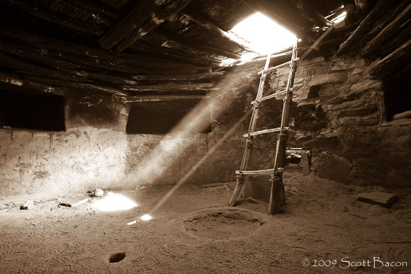
He asked me to choose which image of his I’d like to feature, and my choice was easy.  I chose his image of Slickhorn Kiva, not only because its very well executed technically, but because it conveys the spirit of the Old Ones–the Anasazi who lived in the area–and reminds me why I love this place.


A kiva located in Slickhorn Canyon, Utah

Slickhorn Kiva, by Scott Bacon (used with permission)

Please visit Scott Bacon’s website here, and make sure to subscribe to his blog here.  In addition to these stunning photos from southern Utah, he has beautiful images from the Rocky Mountains, focusing on his home state of Colorado.

Topophilia

Friday, November 6th, 2009

Hi, my name’s Greg and I’m a topophile.

That statement almost makes me sound like I need to check into rehab or begin a 12-step program.  As it turns out, its a good thing to be a topophile.  What the heck is a topophile?  Anyone who has a strong sense of place or identity is a topophile.   Although I have never lived there, I have always felt a strong sense of place in southern Utah.  Having grown up in a home where I was taught to enjoy the outdoors, I do not feel out of place when I am outside anywhere, but I feel especially at ease when I visit southern Utah–its almost as if I’m going home.

When I was 6, my parents moved from Denver to the northwestern New Mexico (the Four Corners area).  I remember a lot of day trips and overnight trips to the La Plata and San Juan mountains, as well as places like Chaco Canyon and the Bisti Badlands.  However, it wasn’t until I was in Boy Scouts (age 12?) that I visited Moab, Utah for the first time.  We went on a mountain biking trip on some local trails, and on the way home stopped at the Needles District of Canyonlands National Park.  To say I was blown away was an understatement.  After that first trip, I couldn’t wait to get back.

My dad, friends, and I had many more trips to Canyonlands over the next several years.  I was not drawn only to the topography and landscape, but also to the archaeological richness of the area.  In some areas, every rock outcropping held a new treasure to see, and to force me to imagine what the ancient peoples thought of this land.  We backpacked in the Dark Canyon Wilderness area, as well as several trips to the canyons of Cedar Mesa, a place I cannot wait to get back to.  Since then, I’ve had the opportunity to explore many of the technical canyons in Zion National Park as well as in the Grand Staircase-Escalante National Monument.

For me, its not so much that southern Utah offers so much in the way of natural beauty, but rather that I feel connected with the land in a way that words cannot really describe.  I’m honored to be able to visit and photograph this place often, and I hope that when my son gets older, my wife and I can instill a sense of place in him (wherever it may be) that my dad helped to instill in me.

Over the next weeks/months I’ll be featuring some of my own photos from southern Utah, as well as other photographers’ work who I really admire.

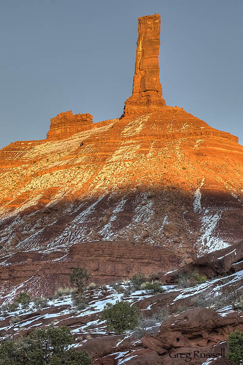
Today’s photo is of Castleton Tower, near Moab, Utah…where it all started for me.

Castleton Tower, Castle Valley, UT, December 2008

Photo of the Month-October

Thursday, October 1st, 2009

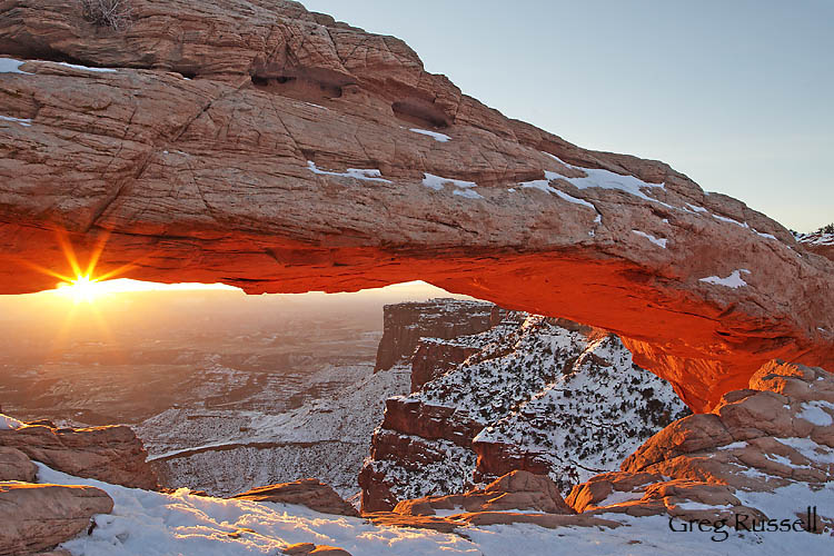
Mesa Arch is probably one of the most-photographed landmarks in Canyonlands National Park, but after watching Ken Burns’ new documentary “Our National Parks: America’s Best Idea”, I couldn’t help but post this shot–somewhat cliché, but one of my favorites.

Mesa Arch at sunrise, Canyonlands National Park, Utah, December 2008

Located in the Island in the Sky District of Canyonlands, Mesa Arch is lit brilliantly at sunrise as light reflects off the walls of Buck Canyon below.  The brilliant light only lasts a few moments, and I was very happy to be able to capture the sunburst as the sun crested the horizon to the west.  Although I’d hoped to experience the arch by myself, I was joined by about 7 other photographers, all gathered in an arc around the arch, but hopefully everyone got shots they were happy with.  To claim my spot, I stood in the dark for ~1.5 hours in 0 degree F temperatures.

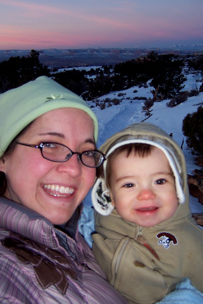
Although I lived in Wyoming, I’m a now a fully acclimated southern Californian making that was a very cold morning, but very worth it.  My wife and son were also able to come along…at the time Owen was only 11 months old:

100_5796Stephanie and Owen Russell, December 2008 (self portrait by Stephanie Russell)
Enjoy and have a great October!

Another image from Bryce Canyon N.P.

Wednesday, September 16th, 2009

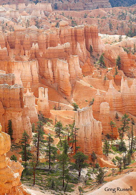
Last night I had time to sit down and process another image from our Bryce fly-by in late August.  Even at about 10am, I was amazed by the glow these formations have.  The ponderosa pines really contrast nicely with the brilliant reds in the rock, and I love the “3-D” feel this image has.

Looking into the Amphitheater, Bryce Canyon National Park, August 2009

Photo of the Day: Thor’s Hammer

Monday, September 14th, 2009

Our recent visit to the Grand Staircase-Escalante National Monument was one of multiple “firsts” for me.  A notable one was my first visit to Bryce Canyon National Park.  I’ve come close multiple times–driving by on the west, north and south, but I’d never been in to see the famous Bryce Amphitheater.  All I really have to say is, “Holy Cow!”  Bryce truly is stunning.

Part of the Claron formation, the rocks in Bryce were deposited by an ancient inland sea and are about 100 million years younger than the rocks in Zion National Park.  The rocks exposed in Zion are younger than the ones in the Grand Canyon; there are, however, formations that are shared by all three areas.  This creates a sequence of superformations geologists refer to as the Grand Staircase.  Bryce Canyon’s formations are the youngest known formations in the staircase.

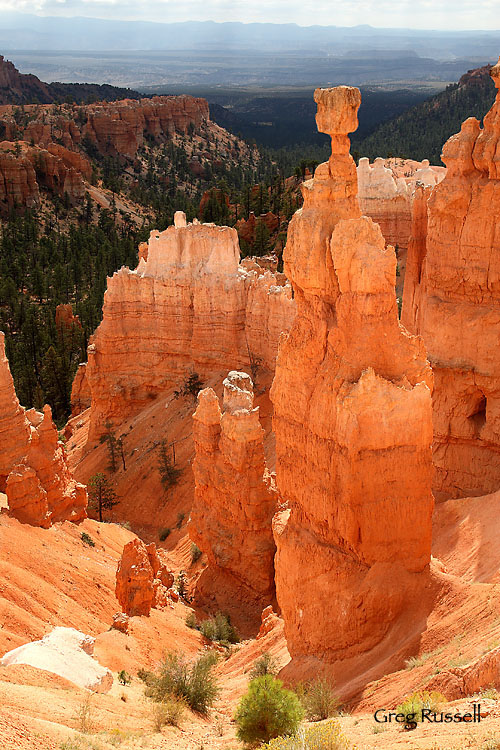
The colorful hoodoos that Bryce is famous for are formed by a chemical weathering process, similar to erosion.  Today’s photo of Thor’s Hammer, the tallest of these hoodoos was taken in August 2009.  I would have wished for slightly better light, but a clearing thunderstorm gave me interesting dappled sunlight, and allowed the limestone to display its beautiful color!

Thor’s Hammer, Bryce Canyon National Park, August 2009


Friday Marginalia

Friday, September 11th, 2009

Another Friday is already upon us, and the photographic community seems to be abuzz with the impending arrival of fall.  There is something about the feel of a chilly fall day that invigorates my senses.

In addition to all of this anticipation of fall’s arrival, we celebrated the birthday of the wilderness act this week!   September is national Wilderness Month, so try to get out there an enjoy one of your favorite wilderness areas.  Incidentally, one of the most moving things I have ever read is Wallace Stegner’s Wilderness Letter, written on December 3, 1960 to the Outdoor Recreation Resources Review Commission in support of the Wilderness Act.

Finally, as an avid canyoneer, I bring up one final point.  Zion National Park is considering permanent parking restrictions on the Canyon Overlook parking at tunnel east, after a park ranger who was directing traffic was hit by the side mirror of an RV.  These parking restrictions would also coincide with further restrictions on backcountry permits given out for canyoneers wishing to descent Pine Creek and Spry Canyon, who use this parking area.  My position is that this would be a mismanagement of the resources available to recreationists (photographers included!)  in the park; I’ve written a letter to Jock Whitworth, Zion National Park superintendent indicating my position as a photographer and canyoneer.  If you would like more info, email me, or visit the Zion Canyoneering Coalition’s website.

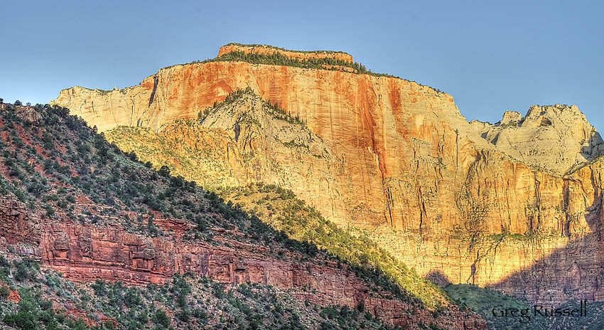
West Temple, Zion National Park, Utah, June 2009

Have a great week!

Tone mapping a single image: RAW or TIFF? A comparison.

Friday, September 11th, 2009

In hindsight this seems like a no-brainer, but since its come up in a few threads recently (e.g. http://www.naturescapes.net/phpBB3/viewtopic.php?f=2&t=162031 ), I thought I would address the question of whether its better to feed a TIFF or RAW file into Photomatix for HDR generation. For this comparison, I chose to tone map only one image, not several. Although you probably already know the outcome, the end images are only subtly different, but getting there was quite different.

I started with a base image, shot in Zion National Park last weekend:

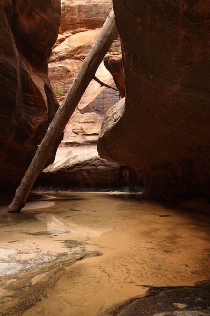
This is the RAW image; all I did before feeding it into Photomatix was adjust the white balance to “shady” in DPP. The TIFF image looked identical; all I did was save it as an uncompressed TIFF with no other change. As soon as I opened the RAW image in Photomatix, it underwent a process of demosaicing and decompressing. I could already tell that it would be taking advantage of the “extra” info in the RAW image. It opened the image as a “pseudo-HDR” image, and I was able to obtain some stats on it:

The TIFF image opened simply as the TIFF image, and there was no more information associated with it than with a regular image. I first tonemapped the images using the Details Enhancer algorithm, and saved them as TIFF files for use in PS. There wasn’t much difference between the two:

Here’s the RAW file tone mapped with DE:

And the TIFF file tone mapped with DE:

Then I did the same thing using the Tone Compressor algorithm:

The RAW file:

And the TIFF file:

Whoa! I can only assume this funky-looking image is the result of the loss of information during conversion from RAW to TIFF early in my workflow. So, now I have 2 tone mapped images obtained from the original RAW file, and 2 from the original TIFF file. My workflow for each of the 2 final images was slightly different although not much:

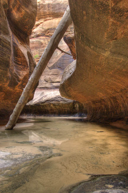
For the RAW-derived images I used the DE tone mapped image as the base image in PS, and pasted the TC image over it. I used the Overlay blending mode at ~30% opacity, and the image looked pretty good. I did levels and curves adjustments (and also a desaturation of about -15), noise reduction with Imagenomic Noiseware, then some sharpening and I called it good:

For the TIFF-derived images, I again used the DE tone mapped image as the base image, and pasted the TC image over it. This time, because of the extreme nature of the TC image, I used a “Linear Burn” blending mode at about 25% opacity, and the image looked pretty natural. After normal processing (including noise reduction), here is what I got:

In the end the differences between the images are subtle, and I like them both for different reasons. The RAW-derived image looks more “natural”, but I sort of like the reddish “glow” that’s present in the TIFF derived image. The no-brainer here is that you certainly lose a lot of valuable information by using TIFF instead of RAW for this sort of application.

I doubt anyone cares as much as I do (haha), but this was an instructive exercise to go through.

One more image from the Subway

Wednesday, September 9th, 2009

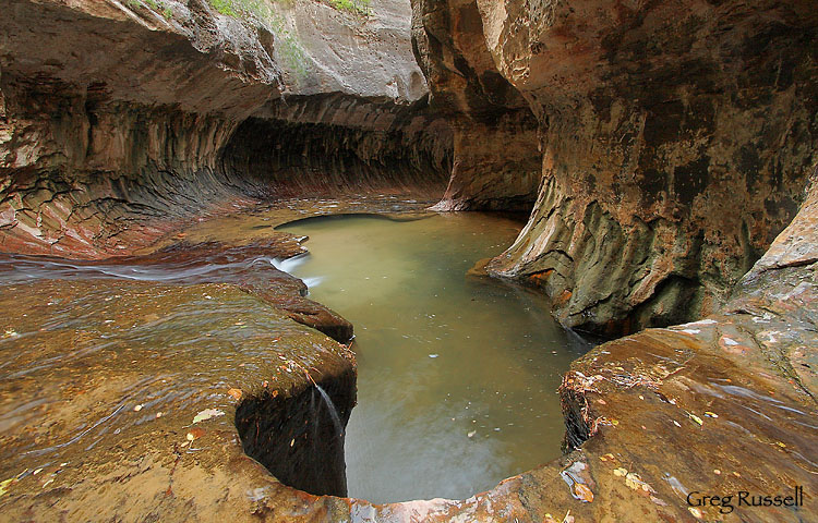
Today I’d like to share one more image from the Subway in Zion National Park.  This image really shows how the feature gets its name: look at how the walls of the canyon curve up like a subway tunnel.

Into the Subway, Zion National Park, Utah, September 2009

I really like how the leaves are scattered on the rock, adding little splotches of color everywhere.  Hope you enjoy looking!